Line of Sight: A Card-Based Overland Travel Subsystem
This is part 2 in a design journal around my 18th century land survey project. For part 1, check here.
Last time I mentioned that I wanted the macro loop of this game to consist of:
- Negotiation: Meeting with the parties interested in the survey and understanding their wants and needs in order to secure salary for more schedule and a bigger crew
- Orientation: Astronomical alignment to the local meridian in order to perform more precise navigation
- Navigation: Overland travel and day-to-day surveying
- Organization: Management and quartermastering of the rest of the crew
Today we are going to talk about Orientation and Navigation as interlocking subsystems that provide structures and generate encounters for the Organization pillar. For both, I'll give a quick summary of the historical principles at play and a little commentary on what I wanted to carry forward into the game.
Orientation from First Principles
One of the honest-to-goodness miracles of humankind is that we found a way to very precisely locate ourselves on the surface of the planet by gazing at the stars. Charles Mason spent 17 nights lying on his back under a six foot sector telescope, lit by candlelight, and two days at a desk performing calculations to determine the exact latitude of a line "fifteen miles south of Philadelphia's southernmost point".
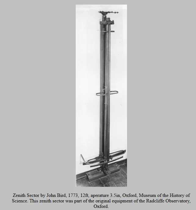
This basically took three steps. First, align the sector telescope with the local meridian (astronomical north-south rather than, like, magnetic north-south). Then, measure zenith angles and Right Ascensions of a handful of stars over a period of time in order to calculate the latitude of this southernmost point. Finally, march exactly 15 miles south and repeat.
This alignment to the local meridian is, I think, the most interesting step to explore as something to make into a game, and it is probably the most legible step of the process. As an astronomer gazes at a star, the earth rotates. This causes the star to follow a small, apparent arc in the night sky. The sector telescope has a set of crosshairs in the eyepiece, so the viewer may watch the star cross this marker and time the moments of crossing with a clock or other chronometer. This then tells the viewer when the star itself is on the meridian, and the viewer can then swivel the telescope to a precise alignment along this line.
If we can determine an enjoyable subsystem to simulate this alignment, then that positions us in fiction for a day's worth of surveying.
Navigation from First Principles
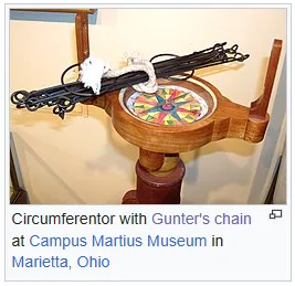
Once your day gets started, your Surveyor and your two Chainers are off to the races. In the 18th century, surveying was performed by line-of-sight using an optical tool called a circumferentor. The Surveyor aligns the instrument with the meridian, determined the evening before by the Astronomer, and positions a crew member along the line of sight to place a stake. If the stake is satisfactorily aligned with the direction of travel relative to the meridian, then the Gunter's Chain is dragged out taut to the stake, the Surveyor marches forward, and resets the line of sight.
This principle of visual triangulation is pretty dang precise as long as the ground is flat. In hilly or mountainous terrain, you need to compensate for slopes and dips by physically raising and leveling the chain, so it is slower going.
I think this line-of-sighting is a fun procedure to abstract and gamify - almost certainly more fun than actually marching circumferentors and chain back and forth across the ground.
Overland Travel in this Game
I want to highlight a couple of things before I get too far into it. I'm writing this and working on this game in Western North Carolina, so I want to acknowledge the past and present members of Indigenous communities that once occupied this land and have been harmed and expelled by settler colonialism, especially the Catawba and Cherokee nations. The Public Land Survey System that I researched to structure certain parts of this game was a project of parceling out land stolen from the people living there and I would be remiss to ignore that.
The core theme that I want to explore here is that the attempt to impose birds-eye rationalization on the surface of the earth is inherently unnatural and produces irrational or fantastical outcomes. The world that the players leave surveyed should be much stranger than they initially found it.
Right now I am representing this strangeness with a currency called Entropy, and as Entropy accumulates it advances the state of the local encounter table. As additional context, days are divided into three phases: Morning, Afternoon, and Evening. Navigation primarily takes place in the Morning and Afternoon, Orientation primarily takes place in the Evening.
Orientation as a Game Mechanic
We briefly discussed how our survey team aligns itself to the local meridian as a necessary step for accurate navigation. This task is performed every Evening. The Orientation procedure is as follows:
- The Astronomer draws five cards from the deck and arranges them in a star pattern on the table. The Astronomer's objective is to minimize the sum of the five cards, with zero representing perfect alignment.
- Red-suited cards are treated as opposite-signed to black-suited cards, so a 7 of Clubs would cancel out a 3 of Diamonds and a 4 of Hearts. Face cards have a value of 10 and Aces have a value of 1.
- The Astronomer may generate 1 Entropy to swap the sign of a single card in the star, i.e. they may generate 1 Entropy to treat a 7 of Clubs as a red-suited card.
- The Astronomer may generate 1 Entropy to discard a single card from the star.
- The final quality of the alignment for the next day of surveying is equal to:
Alignment = 11 - (Remaining Sum of Star)
Thus at the end of the Evening, the Astronomer has generated between 0 and 5 Entropy and produced an Alignment for the following day. These then feed into the Surveyor's activities for the Morning and Afternoon.
Example:
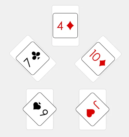
Our red cards sum to 24 and our black cards sum to 13. We choose to gain one Entropy to discard the red Jack and we finish with a final Alignment of 10. Not bad!
Navigation as a Game Mechanic
There are a few pieces to Navigation, so let's break it down piece by piece.
First, surveying is far less efficient than normal overland travel as you can probably imagine from the description above. Take it from Robert Erskine:
It is obvious, that in planning a Country, great part of the ground must be walked over, particularly the banks of Rivers and Roads: as much of which may be traced and laid down in three hours, as could be walked over in one; or in other words, a Surveyor who can walk 15 miles a day, may plan 5 miles; if the Country is open, and Stations of Considerable length can be obtained, then perhaps greater dispatch may be made: very little more, however, in general can be expected;
So let's say that our best rate of surveying on favorable ground is 5 miles (8 km) per day and we'll derate that based on the type of terrain. I didn't want the Alignment to affect that for this system, I wanted the Alignment and Entropy to factor into what the party runs into during their work. So we sort that out according to the following procedure, once per phase of day spent Surveying:
- The Surveyor draws up to [Alignment] cards from the deck in sequence and checks to see if two cards of the same rank, "Doubles" were drawn.
- If Doubles were not drawn, then the game facilitator notes the rank and suit of the last card drawn. The rank of the final card determines an encounter and the suit of the final card determines a negative, attritive effect that afflicts the survey crew.
- If Doubles were drawn, the game facilitator notes the rank of the card and the Surveyor counts the number of cards drawn between the Doubles. Similar to step 2, the rank determines the properties of the next step.
- If the number of cards between the Doubles exceeds the amount of Entropy generated during the previous evening's Orientation, then the survey crew discovers a sign, spoor, or portent of a feature relative to the local area. If there are fewer cards between the Doubles than the amount of Entropy generated during the previous Orientation, then the party is presented with an encounter.
Note: I need to playtest some exception handling for when two sets of doubles are drawn during a Sighting, or triples, or what have you. Honestly two combined encounters would be pretty rowdy!
Example
Above, we have an Alignment of 10 and an Entropy of 1. So we draw 10 cards:
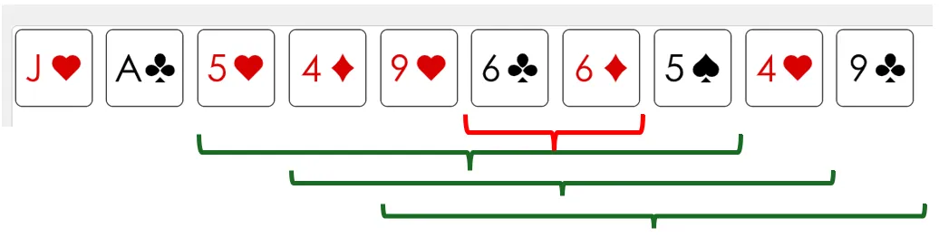
We have Doubles of 4, 5, and 9, but each of them has more than 1 card in between. We also have Doubles of 6 with no cards in between. The facilitator notes this and then refers to their regional encounter table.
Encounter Design and Emergent Play
So what do the subsystems above accomplish? I feel that they thematically turn astronomical observation and surveying into a fairly legible set of card games which result in progressively more entropic encounters. As you'll see, the outcome of the above Sighting is always some form of encounter; as with an overloaded hazard die, something should be discovered at each phase of the day. In support of this, and to support a thoroughly exploration-centered game design, the encounter table really looks more like an expanded version of Dice Goblin's Anchors of Wilderness Play.
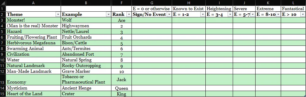
Each card rank is assigned to a feature of the survey area which is known to exist, suspected to exist, or unknown to your patrons. These features are seeded by the game facilitator prior to the survey, either from a procedural generation table or based on your own personal setting. See the table below.
As the survey crew generates more Entropy, the nature of the encounters becomes stranger. The current Entropy of the region is then mapped to the range of difficulty that the game facilitator can impose on Activities that the Steward sends hirelings out to accomplish. This difficulty then becomes the minimum quality poker hand that must be composed based on the set of hirelings.
Example
As the survey team spends the morning sighting across this grassland, they are on track for about 2.5 miles of progress. They notice a few things: there is a smell of rotten fruit on the air, which makes sense for the season, but it's overpowered by the smell of bison manure. The lead chainer also notices some trampled grasses. Somewhere on the horizon to the north there is a rocky outcropping; that will be useful for staying oriented. Progress is interrupted, however, by the tail chainer's pained yelp as his foot punches through some topsoil into a nest of red ants. What do you do?
Looking Ahead
My vision of this is that a game facilitator selects a set of regional features and then projects forward to the most fantastical version of that feature that they can imagine (maybe with the aid of some spark tables), and then the intermediate points on the table are some steps of interpolation between the two. In our example above, the survey crew may task a single blacksmith with pouring some slag into the red ant nest on the first day of the journey. By the end of the journey, the party may be attempting to tame telepathic rock ants to act as replacement pack animals.
In a less bog-standard fantasy example, the party may make notes of a burbling natural spring early in their journey that escalates over time to a subterranean lake with its own climate and ecosystem.
So what are we trying to emulate with this model of encounters and exploration? In 1845, the Florida Office of the Surveyor General issued this directive to surveyors mapping out townships:
You will carefully note the distances from your last corner post to the point where you meet with or leave any lakes, rivers, creeks, brooks, swamps, prairies, hills, roads, canals, or any other natural or artificial object, with their general course; and also take their bearings, so as to establish the position of any important object which you may see on either side of your line, that your field notes may afford a full and accurate topographical description of the country surveyed by you.
Sources of water, notable hazards, landmarks, and sources of potential revenue were all of critical interest to the patrons of these types of survey. They help to orient the next person coming through and they contextualize the value of these plots of land to any prospective purchasers. While the surveyors are trying to build a birds-eye view of the area, they are still experiencing it at ground level and trying to make sense of, to rationalize, the plot of land.
One side note before we wrap up here is that, as I was working through what sorts of contracts/"missions" players in a game like this might have to undergo, I realized that the PLSS 36 square mile standard "township" is the sort of cadastral equivalent of a 6 mile hex, so some missions in this game could essentially be fully exploring and mapping the equivalent of a day's travel in another wilderness exploration game. That feels fun to me! Hopefully it feels fun to some potential playtesters soon :)
Forensic Wetland and Deepwater Habitat Mapping for Setting Pre-development Conditions